BryteCube.
Complex challenges need simple IT solutions.
The AI for Interconnected Information Systems - at the Push of a Button
BryteCube is a knowledge-based artificial intelligence (AI) that generates interconnected geographical information and management systems according to individual requirements at the touch of a button. What sounds like magic is the result of 30 years of research and practical application and is now used by public administrations and infrastructure operators for their key processes.
BryteCube applications are in no way inferior to customised developments in terms of functionality, quality and security. On the contrary! Frequently required solution patterns are ready for immediate use without programming, including project and process management, geodata and measurement data acquisition, e-mail notifications, document management and inventory management with lifecycle management.
Without risk and at a fraction of the time and cost, you can realise your customised information, collaboration and management solution. All BryteCube functions are practice-proven. Your platform organises and links your data and stores it in the right context. This means that you and everyone else involved can find the exact information they need in every situation.
For geographically orientated tasks, BryteCube offers a digital playing field on which all stakeholders can register their needs themselves and coordinate their tasks. The platform can independently make intelligent proposals to coordinate measures and bundle projects. How much time and money can this save you? This allows you and your team to concentrate on the essential tasks and successfully achieve your goals.

BryteCube delivers ready-made solution models, adapted to the requirements of your organisation.
BryteCube.
Complex challenges need simple IT solutions.

Modern Environmental and Infrastructure Management - Effective and Sustainable
Nature and our environment are priceless. Our infrastructures are the work of several generations. Preserving and developing these values is one of the great challenges of our time, which you are committed to meeting.
You are constantly confronted with demands on public space that are difficult to reconcile. Space is limited, communication between the various interest groups is not optimal and there is simply not enough money for many measures.
Everything under Control with BryteCube - the Relevant Information Interconnected
Whoever is active in a geographical space should have all relevant information available interconnected, anytime, anywhere and as easily as possible. We at Condesys Consulting have been pursuing this goal for over twenty years.
With BryteCube, we have created an information platform for our customers in environmental and infrastructure management and equipped it with knowledge-based artificial intelligence. This allows you to set up your own web application with a geodatabase in no time at all, which you and your team can use immediately without programming.
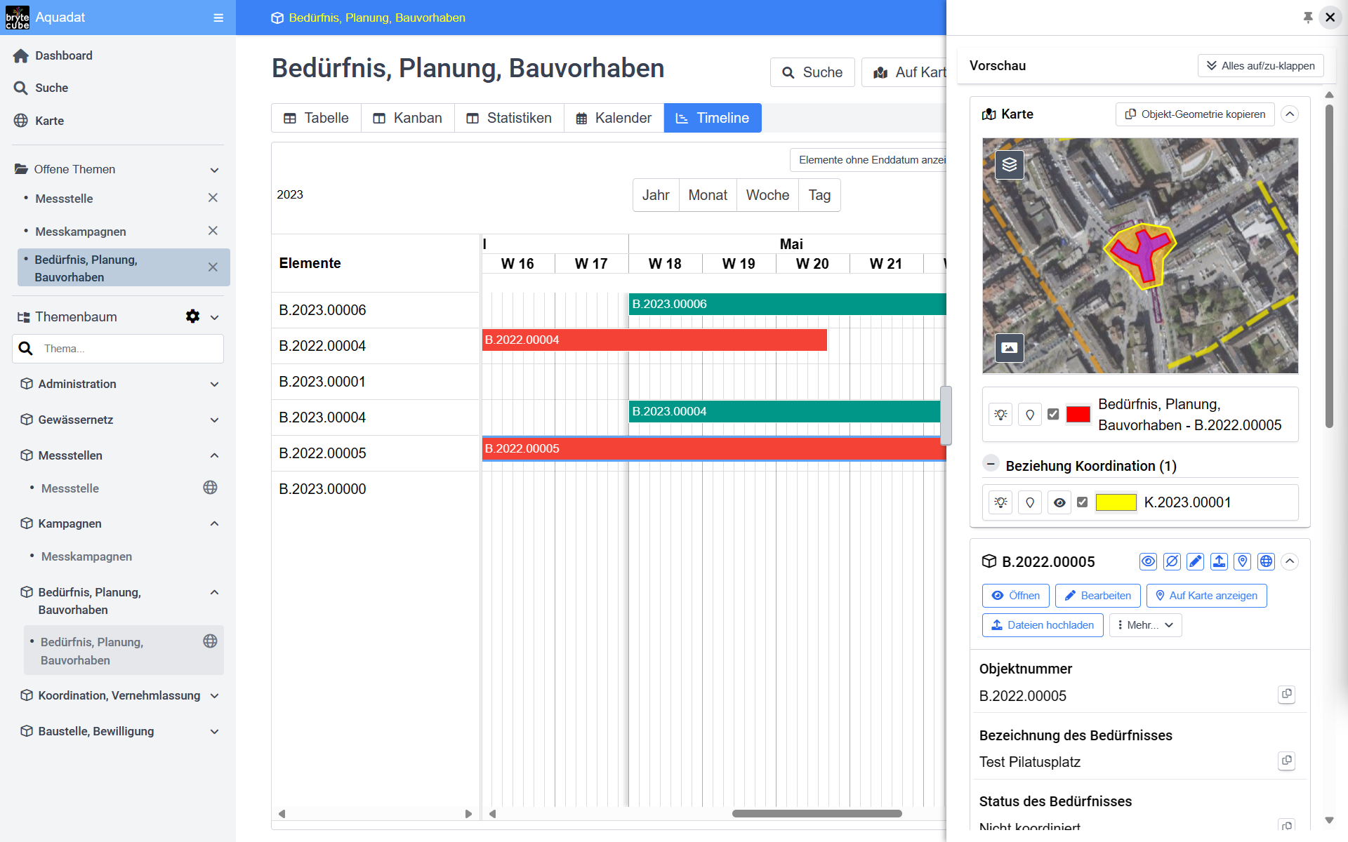
All measures at a glance with temporal and geographical coordination on BryteCube.
You manage your inventories and assets with the associated processes and projects on BryteCube according to your requirements and in a standardised way. You link these with measurement and geodata as well as photos and documents, including e-mail traffic.
BryteCube's applications range from the enforcement platform for the many tasks arising from environmental protection legislation to hunting management, network planning and construction coordination to managing the maintenance of high-performance roads.
With BryteCube, we have minimised the entry barriers to geodatabases and interconnected lifecycle management. The knowledge required to set up a database with geodata is available to you at the touch of a button. You can rely on this because, after all, we are the global pioneers in geodatabase technology according to OpenGIS and have taught data modelling at several universities.
Database structures, web services and web applications are automatically generated from your requirement specifications. With BryteCube, you and your team can get started with your own application in just a few days without having to wait for customised development.
And because the specialists for customised development are ‘built in’ to BryteCube, you are able to expand your information and coordination platform yourself to meet your growing requirements.
Geodata collection in the BryteCube web application by the people on site.
BryteCube in Action
The Key to Success
Coordination in public space
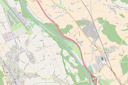
BryteCube and its predecessors have been the tried and tested geographic coordination application on the Internet for over two decades. All participants draw their projects on the map so that everyone knows who has planned what, when and where. Project cost savings of 10 - 25% are common. Accompanying measures for the creation of a barrier-free city, for unsealing to eliminate heat islands and to create a sponge city as well as for the promotion of biodiversity are systematically included in all projects at practically no additional cost.
Like the largest Swiss cities and cantons, your organisation can use BryteCube to manage the entire road infrastructure with traffic lights, bridges and other engineering structures, drainage systems, green spaces, protective structures, pipe networks, etc., record the condition, plan maintenance and repair measures and coordinate new construction and renovation projects with all parties involved.
Everything under control with Kanban task management from BryteCube.
Wählen Sie aus Fachdatenmodellen für Elektrizitäts-, Fernwärme-, Glasfaser-, Kanalisations- und Entwässerungs-Netze usw. und passen Sie sie an die Bedürfnisse Ihres Werkes an. Die Projekt-, Betriebs- und Instandhaltungs-Module von BryteCube sorgen für eine einheitliche Vorgehensweise in Ihrer gesamten Organisation und ermöglichen es Ihnen, ressourcensparende und nachhaltige Koordinations- und Lifecycle-Management-Prozesse einzuführen. Effiziente Datenmigrations- und -synchronisierungsprozesse helfen Ihnen zudem, die bestehenden Daten rasch und qualitätsgesichert auf Ihre BryteCube-Datenplattform zu bringen.

Ob Glasfaser, Elektrizität oder Fernwärme, mit BryteCube ist Ihr Fachdatenmodell sofort einsatzbereit.
BryteCube ist in wenigen Tagen betriebsbereit als Ihre Plattform zum Austausch von Projektinformationen, für die Bildung von koordinierten Projekten, für die Vernehmlassung zur Einholung von Stellungnahmen aller Beteiligten und Betroffenen und zur Auskunft über bevorstehende und laufende Baustellen. BryteCube ist Ihr digitales Spielfeld für die systematischen Koordination im öffentlichen Raum. Gewerbe und Bevölkerung danken Ihnen jede Baustelle, die vermieden werden kann.

Interconnected platform for the implementation of legislation on the environment, forests and agriculture
Environmental authorities in Switzerland and Liechtenstein have been relying on BryteCube for years. They systematically record all environmentally relevant installations as part of authorisation procedures. The data for environmental monitoring with inventories, mapping and measuring points is available on their BryteCube platform. Current measurement data is continuously fed into the database, documenting the state of the environment, the impact of our activities and the effect of protective measures.
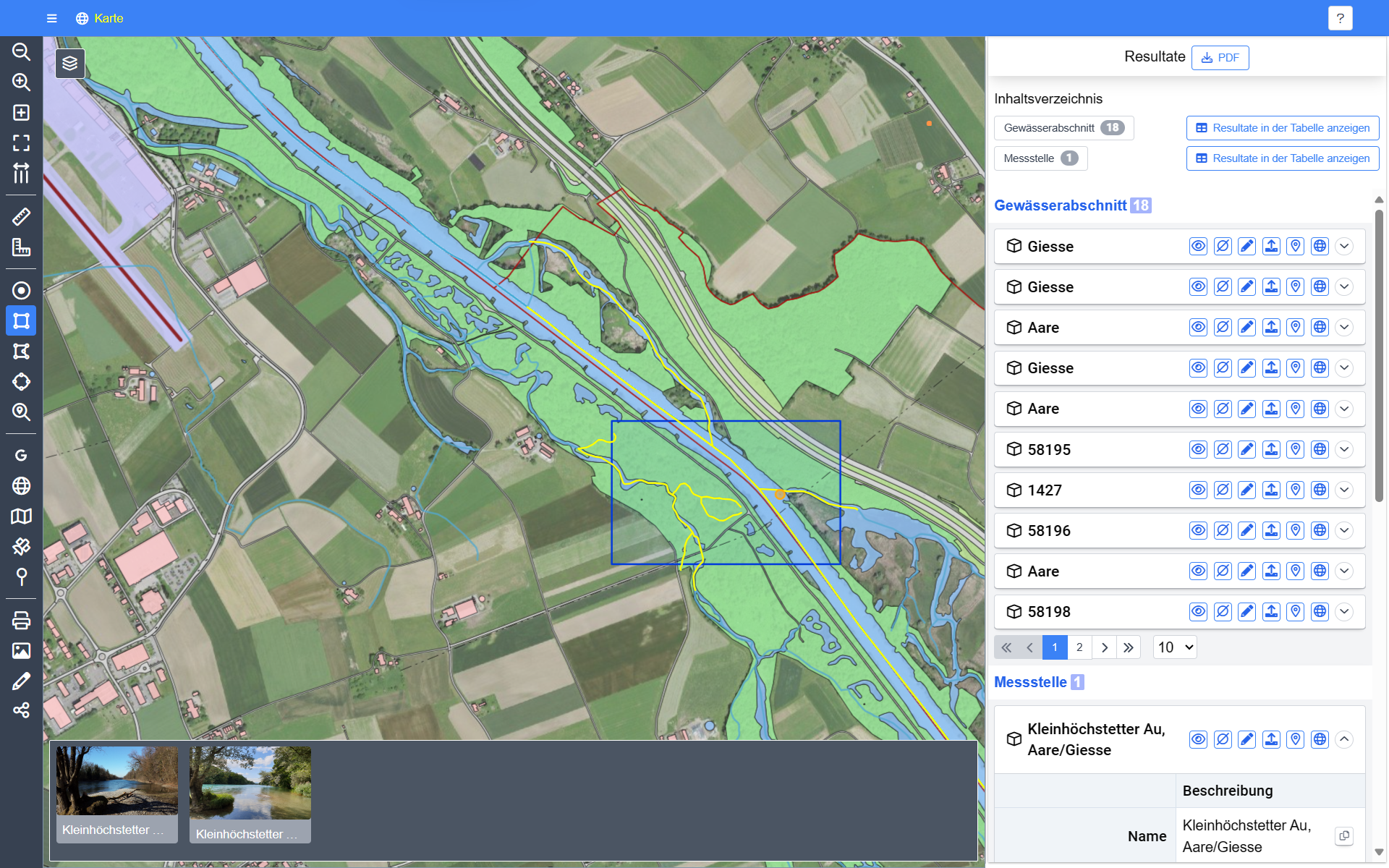
A spatial query in the BryteCube database immediately provides all measuring points and inventories for further processing.
All permit applications are coordinated in a standardised process between the specialist departments. Compliance with environmental protection requirements is checked on the basis of the latest data and is largely automated thanks to integrated geodata management. This saves time and ensures satisfied applicants. Authorisation documents and the associated invoices are created at the touch of a button.
BryteCube's simple web applications are also immediately available to you with GIS functions, measurement data management, photo, document and e-mail management, project and task management and much more. No more searching for documents! With BryteCube, all your basic data and business information is immediately available for processing in the web browser. Whether on the move or in the office, everyone involved can quickly access new information in the right context. This simplifies communication for you and your team and speeds up processes and decisions.
Wenn Ihre GIS- und Datenbankanwendungen in die Jahre gekommen sind und ihren Zweck nur noch begrenzt erfüllen. Wenn unzählige Excel-, Access- und Shape-Dateien auf Ihren Dateiablagen herumgeistern. Dann gewinnen Sie mit BryteCube Ihre Handlungsfähigkeit zurück.
In wenigen Schritten bringen Sie Ihre Inventare und Vollzugsprozesse auf eine geordnete Datenplattform und verlinken sie mit den dazugehörenden Mess- und Geodaten sowie den Dokumenten, Fotos und dem gesamten E-Mail-Verkehr.
Mit BryteCube benötigen Sie keine komplizierte GIS-Software mehr. Alle Daten können direkt im Web-Browser editiert werden. Abfragen und Auswertungen erfolgen direkt in der Datenbank.
Ohne Programmierung erstellen Sie mit BryteCube genau die Anwendungen, die Ihre spezifischen Anforderungen erfüllen. Fachdatenmodelle übernehmen Sie auf Knopfdruck. So optimieren Sie Ihre Prozesse und reduzieren nachhaltig Ihre Kosten.
What are you waiting for?
Bring the future into your business!

Our Promise to You: Your Information System as an Immediately Running Prototype after Our Initial Consultation
You have important tasks to do and you have set yourself the goal of making things better. You have chosen one thing you are interested in and for which you are willing to go new ways. What is your most urgent challenge? With BryteCube from Condesys Consulting, you can easily manage your most complex data and processes.
With the use of BryteCube as your integrated information platform, you can substantially reduce your risks. You and your team are ready for operation in a few days. You can implement new requirements quickly, cost-effectively and according to your specific requirements at any time. The typical BryteCube customers – mainly environmental authorities and infrastructure managers – are launching with a few urgent data sets and processes. After a short time, they have adopted fifty, hundred and more topics interconnected from their databases and made them available uniformly throughout the entire organisation.
Proven solution patterns at the touch of a button speed up the structure of your new information and coordination platform on BryteCube and reduce your risks.
BryteCube helps you organically switch your processes and your organization to a contemporary and sustainable environmental and infrastructure management. So that they are able to meet the challenges of today and the future.
Let us know your most urgent challenges. After our initial consultation, we will already show you a running sketch of your new information and coordination platform on BryteCube. Contact us without obligation under info@condesys.com.

BryteCube has a scalable IT infrastructure, magically controlled by knowledge-based artificial intelligence.
20 Years Condesys Consulting
2004 - 2024
The innovative solutions from Condesys Consulting have had a lasting impact on how information systems with geographical data are set up and utilised. BryteCube has massively lowered the barriers to the use of individual co-operative information solutions. At our birthday event, we look back on our pioneering innovations of the last 20 years and look ahead to how our customers are confidently realising their visions with BryteCube in order to master their current and future challenges.

"I Have Seen the Future"
In 2004, after selling his EPFL start-up GeoTask AG, Dr Martin Huber founded Condesys Consulting GmbH in Basel.
GeoTask AG brought geodatabase technology a decisive step forward in 1998 with the world's first implementation of the OpenGIS standard for SQL. Condesys Consulting then opened up the immense possibilities of standardised geodata provisioning for practical use. The first 10 years of Condesys Consulting were characterised by the design and implementation of solution architectures for sometimes gigantic infrastructure and environmental management systems, including the system for the management of Swisscom's entire physical network and its system for the agile fibre optic rollout, as well as the architecture of the North Rhine-Westphalia road information system NWSIB with integration of 14 specialist systems for an organisation with 6000 employees (Video: NWSIB in short).
The second decade was dedicated to the development of BryteCube. BryteCube is a knowledge-based artificial intelligence (AI) that also enables medium-sized and small organisations to set up a comprehensively interconnected information system with integrated geodata management according to their own needs. BryteCube has been used successfully for years in environmental and infrastructure management.
BryteCube is used to organise and coordinate projects and measures in a geographical space with a focus on the life cycle of the infrastructure and maintenance of its value (e.g. planning and construction coordination of the city of Bern with 40 participating entities and the maintenance of the Gotthard national roads). BryteCube is particularly suitable when complex processes with many participants have to be handled across organisational boundaries (e.g. organisation of the management of wildlife habitats in the canton of Graubünden or the platform for the implementation of environmental protection legislation in the canton of Basel-City).
BryteCube is also the platform for consolidating heterogeneous databases with spatial and temporal references. BryteCube enables specialists to manage the data for their complex conceptual and operational tasks themselves, without having to go through a GIS or IT department (e.g. environmental data cadastre Liechtenstein and geodata management of Grün Stadt Zürich).
With the international RemiPCA SAFE Network, which our Co-Managing Director Dr Andrea Anna Melber has established with 40 hospitals, BryteCube proves its universal applicability for digital collaboration across organisational boundaries with complex data and process requirements.
Celebrate 20 years of Condesys Consulting with us
Condesys Consulting has been at the forefront of innovation for 20 years with the aim of creating simple IT solutions for complex requirements. Celebrate our birthday with us on the 26th August 2024, together with our customers, BryteCube users and our partner companies.
Register without obligation at E-Mail info@condesys.com, if you would like to take part in our celebrations, so that we can plan the size of the event.

20 Years Condesys Consulting
2004 - 2024
BryteCube.
The information platform that evolves with you.

Your data take the centre stage
BryteCube is like a magic cube that links your data on inventories, processes and projects with time, location and organisation. Knowledge-based artificial intelligence (AI) enables you to independently set up a comprehensive information system that is customised to your requirements and improves your work performance efficiently and effectively.

Data organisation & data models
Everything that makes up a data-intensive web application, i.e. data structures, measurement data parameters, application pages, etc., is configured in BryteCube with a web application.
BryteCube generates the associated database structures, web services and application components from your data structure descriptions (metadata) at the touch of a button. An application for a geodata set, for an implementation task in accordance with environmental protection legislation or for the maintenance of facilities and infrastructures can be realised with BryteCube in a matter of hours or days.
What BryteCube offers for data models and data maintenance:
- Own data models as well as predefined standard data models for typical tasks in environmental and infrastructure management.
- Transfer of data models from UML (XMI), Interlis and existing databases.
- Data query with freely definable query criteria.
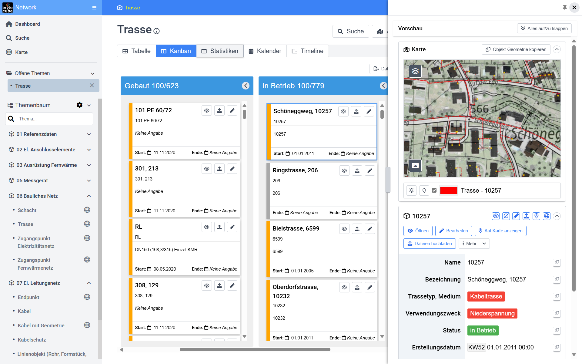
- Visualisation of data as a table, Kanban board, calendar, interactive timeline (Gantt chart) and map.
- Recording and editing of data records in web forms.
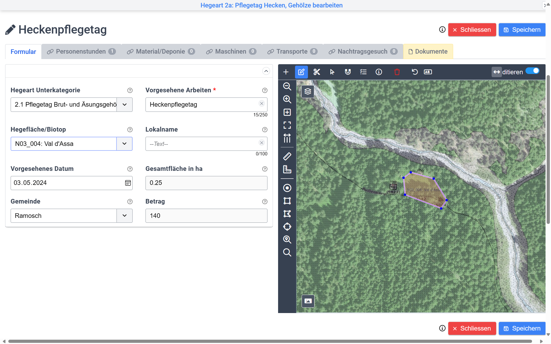
- Capture and edit geodata such as points, lines and areas directly on the map in the web browser with snap functions for precisely customised geodata.
- GPS positions and photos on site are recorded directly from the mobile phone into the web form.
- Import and export via Excel, Geopackage, FME and GDAL/OGR.
- Interactive editing with desktop applications such as Excel and QGIS.
- Multi-user operation with fine-grained authorisation system.

Tasks, processes, projects & coordination
Modern data management is used to organise your own world according to your own needs and to maintain an overview at all times. This is why BryteCube allows you to attach tasks, notes, work reports or simply a notepad to each object. Teams or individuals can be automatically notified of important events with a link to the relevant data record.
BryteCube supports your own work organisation, coordinated team collaboration and the long-term management of environmental resources, facilities and infrastructure.
What BryteCube offers for tasks and projects:
- All objects can be linked to tasks that are managed in a standardised way throughout the system.
- Customised task structure, from notepad to scheduling and resource planning to time and cost accounting.
- Filter functions that extract only the currently essential tasks from thousands of tasks.
- Clear visualisation in lists, Kanban boards and Gantt/timeline charts with interactive queries and further processing of individual data records directly from the chart.

Documents, photos, emails & reports
Important information is stored in documents and photos. BryteCube makes it possible to link data records with documents or upload the media directly to the object and manage them together.
Linked and always to hand: The photo in the right place, the current circuit diagram right by the distribution box, the instructions for the device or correspondence on a business case.
The document storage can be set up directly in BryteCube or linked to document management (DMS) and enterprise content management (ECM).
BryteCube generates documents, map extracts and Excel files for all kinds of applications. QR invoices for billing or pivot tables for the statistical analysis of measurement data are just as much a part of the product as high-resolution map printouts in any size format.
This is what BryteCube offers for documents, photos, emails and other media:
- Each data record is linked to the document management system.
- Linking and uploading in the web browser with drag-and-drop directly from Outlook and from the file repository.
- Photos from mobile devices are transferred directly to the web form and are available online to all participants immediately after uploading.
- Query and view all documents for an object.
- Export to combined data packages such as QGIS layers with document link.
- Own document storage and linking to DMS and ECM.
- Document generation with standard format as PDF or with customised layout based on Word templates.
- Professional map printing, high-resolution and in any size up to A0.
Geodata
Every object in BryteCube can be localised with one or more geometries in geographical space. Geodata can be edited directly in the web browser with minimal effort. Any map layers, such as survey data, can be used for snap functions. This allows you to create your own geodata precisely and accurately.
On the move and in the field, the GPS position centres the map on the current location. Querying all information at the location and transferring the GPS coordinates for recording new information makes it easier to work on site. The georeferencing of all data - where appropriate - increases the effectiveness of the information system many times over.
In two respects, geodata processing with BryteCube cannot be surpassed by any classic GIS tool:
- Usability: Since the beginning of BryteCube's development, the focus has been on the use of dynamic geodata in work processes. The more than twenty-five years of experience with transactional geodata applications via the Internet in BryteCube's DNA have achieved incredible things: for the canton of Graubünden, an application for a complex authorisation procedure for one thousand affected farms was created and put into operation in two languages within ten working days. The complex application, including geodata acquisition, could be used immediately by non-experts without any training. Since then, other similarly complex applications have clearly demonstrated that BryteCube is the undisputed leader in web-based geodata processing in complex processes with many participants.
- Performance: The combination of database storage of geodata with geographic indexing and database functions is superior to any other known method in terms of performance with large volumes of vector geodata. Traditional GIS tools cannot fully realise this potential, whereas BryteCube's GIS architecture optimises everything from the web browser to the database. This unique expertise can be found in BryteCube's AI generators, from which every application created with them benefits.
BryteCube is GIS 4.0, an interactive, multi-user and multi-purpose geodata warehouse with import and export as well as online and offline processing in many tried-and-tested scenarios.
What BryteCube offers for GIS, map applications and geodata services:
- Geodata is captured where it is created and entered directly in the web browser or on the smartphone.
- Tailored and optimised geodata structures in the database.
- Objects can be provided with multiple geometries, e.g. for GPS tracking, historisation and other multi-representation tasks.
- Set up a geodata infrastructure according to best practices at the touch of a button.
- Full utilisation of the data in classic GIS tools such as FME and QGIS.
- Combination with measurement data for dynamic real-time maps.
- Direct import of geodata via the web in OpenGIS geopackage format or as OpenGIS WKT in simple Excel files.
- Integration with FME and GDAL/OGR for powerful ETL processes.
- OData web services with geodata queries and geodata transactions (OASIS web standard).
- Interactive editing of BryteCube data with QGIS directly on the database.
- Online map services for BryteCube data based on QGIS server and map server.
- Extraction and offline editing with QGIS and other desktop GIS and mobile GIS devices with seamless transfer of the modified offline data back to BryteCube.

Observations, measurement data, measurement networks & measurement campaigns
All observations and measurements fully documented: Complex measurement series often disappear in confusing tables and file systems. The BryteCube measurement data module creates order here.
Every object in BryteCube can be immediately linked to measurement data with minimal configuration effort. Measurement data ranges from textual observations and code lists to comprehensive measurement programmes with many measurement parameters or sensor data.
All measurement data is fully documented (unit of measurement, measurement method, etc.), so that even years later it is always clear what was measured.
What BryteCube offers for observations and measurement data:
- Structured measurement data management for each object without programming.
- Complete documentation of each measured value through defined measurement properties.
- Measurement campaigns with a combination of different measurement parameters at the same time and in the same place.
- Simple import and export in Excel format, including pivoting.
- Direct access to measurement data from the web and with desktop applications (statistics, GIS, monitoring and control of systems).

Interoperability
BryteCube is designed for interoperability because the data about the environment, your assets and infrastructure often lives longer than the software used to create it. With BryteCube, you are prepared to collaborate across systems and protect your investments in the long term.
BryteCube quickly and systematically organises extensive data collections while maintaining a reference to the surrounding systems at all times. A globally unique key system and structured metadata make your data system-independent. The data "explains itself" so that it is also prepared for future requirements and use cases that are not yet known.
BryteCube massively reduces the risks of system replacements with evolutionary and agile migration scenarios. Systematic references to connected objects in other systems enable simple interfaces and cross-system process handling.
Your data is securely protected thanks to fine-grained authorisation management and integration with widely used standard authentication systems.
BryteCube's interoperability protects your investments in the long term and gives you the freedom to use the most suitable tool for every task.
What BryteCube offers for integration & interoperability:
- System-independent keys with GUID (Globally Unique Identifiers) throughout.
- System-independent metadata.
- Systematic storage of references to linked objects in other systems (data warehouse).
- Open interfaces (OData) with end-to-end access control.
- Offline and online distribution with scalability and consolidation.
- Comprehensive rights management through integration with E-ID, OAuth, OpenID Connect, Active Directory and LDAP.
- Generic interfaces for external service calls from the web application and from the server.
Environmental and Infrastructure Management
Efficiently organised, comprehensively connected
BryteCube by Condesys Consulting
Ready to use immediately for your work